Ice Age development and Human Settlement in northern Eurasia (ICEHUS II) – coring lakes for climate and environmental reconstructions in the Russian Arctic
ICEHUS is an ongoing interdisciplinary research project that is financed by the Research Council of Norway for the period 2005-2009. The project studies the Late Quaternary environmental changes in the Barents-Kara sea region and the earliest human occupation in northern Russia. We consider IPY as a golden opportunity to provide for a further development and continuation of this long-term Russian-Norwegian collaboration. In this project we will carry out a lake coring programme in the Russian Arctic that in our opinion may provide unique archives for reconstruction the climate and environmental evolution in the Arctic (Fig. 1). If successful, these cores will be a source for research for many years ahead.
Research questions, hypothesis and choice of methods
As discussed above, successful coring of lake basins that contain long records of lacustrine sediments will be a path-breaking achievement that may lead to a much better understanding of the climate and environmental evolution and more reliable correlation with the marine record in the Arctic Ocean and elsewhere. Different approaches and questions that will be addressed through the coring programme are outlined below.
The climate
evolution through the last interglacial-glacial cycle
One target will be to obtain sediment cores that reach the last interglacial (130-115,000 years ago) and possibly even further back in time. Our previous investigations reveal intriguing climatic shifts during the Early Weichselian, and there is evidence to suggest that some interstadials were even warmer than at present.
One target will be to obtain sediment cores that reach the last interglacial (130-115,000 years ago) and possibly even further back in time. Our previous investigations reveal intriguing climatic shifts during the Early Weichselian, and there is evidence to suggest that some interstadials were even warmer than at present.
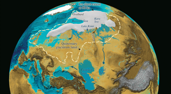
Northern Eurasian ice sheet extent
at 90,000 years ago with ice-dammed lakes and
rerouting of drainage. Also the Quaternary glaciation limit is shown.
rerouting of drainage. Also the Quaternary glaciation limit is shown.
The number and stratigraphic position of ice-dammed lakes
Potentially, this project will enable us to determine how many ice-dammed lakes, and thus also how many expansions of the Barents-Kara Ice Sheet that have occurred since the last interglacial and to obtain a more precise chronology.
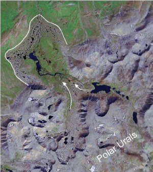
Glacial development of the Polar Urals
Our investigations have shown that the Urals were not covered by a continuous ice cap, but that outlet valley and piedmont glaciers existed some 60,000 years ago, and that the local glaciers were only slightly larger than the present small cirque glaciers during the Last Glacial Maximum (22-20,000 years ago). We propose to test this hypothesis by collecting sediment cores from selected lakes, and refine the glacial chronology through identifying and dating melt-water deposits that originated from the upstream glaciers. Local glaciers can be reconstructed from lake sediments combined with geomorphological mapping. This will provide a direct linkage to temperature and precipitation variations.
Satellite image from the Polar
Urals showing local moraines and lakes, the latter being potential
coring sites. Distal part of moraine and ice flow directions are
marked. From Google Earth.
Humans and climate
From the sediment stratigraphy at the archaeological sites we have inferred that the periods with human occupation correspond with relatively favourable climatic conditions. During the peak of the last glaciation (25-15,000 years ago) a much colder and windier climate prevailed, and the landscape was much less productive. We intend to reconstruct the physical and biological environment before, during and after the recorded settling periods in order to asses the human adaptation to the physical environment.
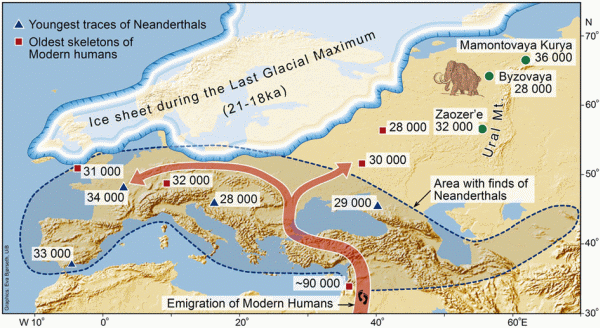
Map showing the LGM ice sheet and
European Palaeolithic sites, modified from Pavlov et al. (2001).
Project plan
The field investigations will be carried out as a joint effort by research teams from Bergen and from Russia. The coring will mainly be carried out during the winter seasons in 2007 and 2008, with additional field work during the summers. The core material will be shipped to Bergen for initial processing where several persons will contribute to the analyses of this material. The field work, sediment analyses and interpretation of the core material will represent a major scientific challenge that will contribute to develop the national research competence, both in Norway and Russia. This will represent a further development of the scientific collaboration which started 13 years ago. Analytical data will be archived in the established climate database at the Bjerknes Centre for Climate Research.

Heavy drilling equipment used in
previous coring from winter lake-ice in northern Russia.
Project management, organisation and cooperation
Project Leader:
Professor John Inge Svendsen (member of the APEX international steering committee)
Other participants from Bergen:
Atle Nesje
Jan Mangerud
Jostein Bakke
Richard Gyllencreutz
Mona Henriksen
Herbjørn Heggen
Øystein Lohne
Linn Karlsen
Ingrid Drange
Kristian Vasskog
Cooperating institutions from Russia:
VSEGEI (National Geological Institute) - Alexei Matiouchkov
St. Petersburg University - Dmitry Nazarov
NIIKAM (Institute of Remote Sensing Methods for Geology) - Valery Astakhov
The project forms part of the programme APEX (Arctic Palaeoclimate and its Extremes) that has been selected as a lead coordinating programme (IPY cluster) for palaeoclimate research.
Members area
(password required)
(password required)